 |
| Santa Fe River Trail - Alameda & St. Francis |
What's old is new again. Last fall saw some serious
rehabilitation of the Santa Fe
River west of Camino
Alire and Bicentennial Park. The city was constructing a couple new miles of the Santa Fe River Trail,
one of five main alignments in the
city's new urban trail system. The work
included completing the trail section between Camino Alire
and Frenchy's Field (along Agua Fria). An
existing but intermittent dirt footpath was graded, widened, paved, benches and
trailheads were put in, a bridge was installed, and the river bed itself was
cleared, re-channeled, and armored in places against erosion. Toward the end of
last year I steered a few of my runs through here to monitor progress and
there were still major pieces awaiting completion.
Ah, but I trekked down there again this last weekend because
of the city's annual water release from the reservoir - part of the 'living
river' ordinance put in place last year. It's a wonderful thing to run or ride, or just
generally pass the time along a flowing waterway. Particularly so for the Santa Fe River in which one seldom sees a flowing current. To my surprise, the new
section of trail was complete - and there were all kinds of folks walking and
running and riding along, enjoying the day. There were half-naked kids playing
in the water, making excited kid noises, floating makeshift boats and engineering
sand-and-cobble dams. And quite amazingly, there were hundreds, maybe a few
thousand planted saplings all throughout the sandy new riverbed from Camino
Alire to Frenchy's field. I almost couldn't believe what I was seeing. It
must've taken dozens of people and hundreds of hours to have completed that
work. It looked fantastic.
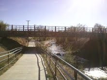 |
| The underpass at Camino Alire |
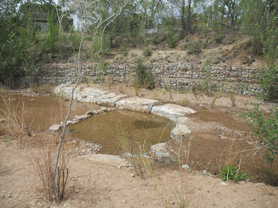 |
| One of the many new pools, with current, sunbathing stones, and saplings of willow and cottonwood |
 |
| Willow saplings along the rehabilitated riverbed |
|
 |
| Looking south along the river. The new trail sits on the upper left |
 |
| (A crumby image) looking north from the pedestrian bridge. Water, the Sangres, and a soon to be forest of saplings |
I wondered to myself how long it had been since the Santa Fe River had looked this grand. Fifty
years? Sixty? Since the public works projects of the 30's? It's never resembled anything close to this in my lifetime and
I'm closing in on forty.
 |
| Footpath along the river, a few blocks north of Canyon Rd |
The River Trail now stretches unbroken
from Frenchy's Field
to Delgado St east
of downtown Santa Fe.
One can navigate the rest of the way to Patrick Smith
Park by sidewalk or by an
un-maintained footpath along the riverway.
The adventurous can wander further up
the Access issues along privately maintained Camino Pequeno now require hikers/runners/bikers seeking to wander the little known Santa Fe River Preserve to seek public access from either Upper Canyon or Cerro Gordo (
more below). On the western terminus, the county has
completed a small stretch of the trail through Agua
Fria Village and
Camino Real Park, with
plans to connect east to the newly completed city section, and eventually
westto the Polo Grounds near the Santa
Fe Airport.
Trail Update (7/3/14): I have received notice of repeated trail conflicts on the Camino Pequeno lead-in to the SF River Preserve, and have been asked to clarify the trail through here. Residents tell me that the road itself and adjacent property are
not a public thruway. It's unknown if there may be a public easement along the river itself, however, there is currently no formal trail alignment through here. These seem like good people that are increasingly frustrated about this problem. Please respect these folks' privacy and access the Preserve via Upper Canyon and/or Cerro Gordo.
I am a resident of Camino Pequeno - The road is a private way (clearly posted) and was not designed for public access. We wouldn't mind people enjoying the river, if they stayed along side it or traversed the other side, but people have started cutting through yards and congregating on the road which is both invasive to our privacy and in some cases has resulted in destruction of property. Having cyclists fly down it is not only hazardous in such a confined area, but it destroys the serenity for residents...Both Cerro Gordo and Upper Canyon Road have legal [public] places to park and provide open-access routes through the city easements and arroyos to the trails along the river. Thank you for being alert to the issue! I and the other residents appreciate it! Best Regards, D.B.
Related Posts:
-
Moon Mountain Trail
-
Apache Canyon Trail Loop
-
Acequia Trail Underpass - All Queued Up
View Santa Fe River Trail - Santa Fe, NM in a larger map


Camino Pequeno is NOT a hiking trail or a dog park. Please consider using one of the public roads adjoining the nature preserve. Pequeno is a private road wholly owned by the residents on both sides of the road and right up to the river. It has been my experience the residents are becoming greatly exacerbated by random strangers walking the road and have started reporting people, dogs off leashes and cars that do not live there.
ReplyDelete*... the resident's privacy frustrations are becoming greatly exacerbated...
ReplyDeleteAdvertising their road as a public access trail is a bit like someone else advertising your personal front yard as a new city park.
Well, none of this sounds good. Access conflicts at the Santa Fe Preserve. Sounds like the access stretching between Alameda and the Preserve is not public. This concerns a short 200m roadway on the extreme east end of the River Trail, only. The five miles of trail stretching west to Frenchy's field are city owned, and the eventual twelve mile route stretching to NM 599 will be city/county owned and managed.
ReplyDeleteI'm very alert to privacy issues and trail access conflicts, and I'd agree that presenting a private lot as public would be a disservice. That's not the way I've presented it here. If you'd like to chat about possible route alternatives (Cerro Gordo?) send a line to highdesertdirt@gmail.com
It would seem like the best solution is to publish a map with the access route to the preserve. The pequeno folk have been under stress as the road have been declared a floodplain or worse and dire threat of mother nature washing them away. Just say where to park and how to get to the river walk.. Is this not common sense?
ReplyDeleteThe comment above is one of several I have received regarding this user conflict. All are similarly unhelpful and accusatory in some way (save the marvelous note from D.B. that I re-published in the post above). And most are eager to point out their obvious deficiency in map reading skills.
DeleteProtip: If you have access complaints about area trails one ought to work out the problem with your City Councilor(s) rather than anonymously post childish comments to a blog.
Is there really an access point from upper canyon?
DeleteIs it conceivable to stay in the river wash, in dry times, through here without disturbing the residents? Obviously this won't work for the cyclists and people cutting through yards and congregating.
This would seem to correspond with the residents quote of "we wouldn't mind people enjoying the river if they stayed along side of it or traversed the other side.
I'm guessing they don't own the river itself.
Maybe this is a stretch on a sensitive issue.
Thanks for the post
Appreciate the comment and feedback.
DeleteThere is access to the Preserve from Armijo Lane and Cerro Gordo Park as designated on the map. There is additional access from the far east end at the reservoirs, but access here is similarly limited as the trail runs into private property after 1/2 mile. I know of no other public access from Upper Canyon. If the city holds an easement along the (south embankment?) of the river in the Pequeno area, as some seem to suggest, they have yet to develop or sign it as public use as far as I know.
I use to live at the corner of armijo and cerro gordo and would use this passage often. But as I recall, I thought there was a sign at the bottom, as in coming up out of the river, reading private, not for public use. Or something to that effect.
DeleteI always assumed this was the issue around here before the pequeno thing raised a stir. If this access is legit, well then cheers to that!
Within the entire river trail, it's a shame there is a gap here. Conceptually it really could have made for a continuous flow to the Dale Ball TH up the arroyo trail heading to cerros colorados. Just a small walk down gordo from the park.
I know further up the new Piedra trail connector is a huge break through, connecting the greater mountain. But there still is not that "seamless" connection from town. This is what they sole heartingly promoted the piedra as, the connection from town. More like the colorados parking lot.
This river trail would be it! Walking cerro gordo from gonzales is a nightmare.
Does any one else recognize this?
May the city grant us one more step! Or the residents.
Some of us go big!
Public vs. private is a blur in this area. This is why people are upset. It has been suggested by other users that there are alternative access points to the Preserve than Pequeno, but the only ones I'm aware of are at Armijo Lane and Cerro Gordo Park (which is actually Adam Armijo Park now). Nobody has clarified or confirmed this because nobody seems to know.
DeleteI'd agree that the Preserve would be the best and most obvious connection from town, extending the SF River Trail right up to Randall Davey and Dale Ball. I'd highly recommend badgering your City Counselor and County Commissioner about this. Ask them what the master plan is for this area.
An alternative link to the mountains: Arroyo Saiz connects through from Palace Ave though not a defined trail. A better network to the backcountry flows from the north. Museum Hill/St John's sends all the way through to Winsor/Pacheco only crossing Artist Rd.
There is no public land or wildlife preserve within close proximity or
ReplyDeleteconnecting to Cam. Pequeno: The Neighborhoods of Santa Fe, New Mexico-Open
House http://goo.gl/fb/CKlpqQ
Here is the correct link: The Neighborhoods of Santa Fe, New Mexico-Camino Pequeno http://
ReplyDeletegoo.gl/fb/q9C15F
I was told there was a arroyo mora that one could walk up to the preserve. Is this true? Is there not a city official who would know where the exact public trails / easements are ensuring private property is not trespassed accidentally. Would like to at least be able to walk along the river but confused now as to where it is permissible.
ReplyDeleteArroyo Mora crosses under Upper Canyon Rd 200m east of Camino Cabra. It runs along the east boundary of the new Water Shed Park on the north corner there, directly into the SF river south of Barrio Pequeno. I'm unaware if you could follow along the fence line to the Preserve but this would be a terrific access point since it's city owned.
DeleteOur current slate of city councilors are listed here. Call or send an email about this problem and report back if you get some answers. Not sure if anyone has taken ths approach yet though it's the most direct. http://www.santafenm.gov/elected_officials