Wednesday, December 26, 2018

South Mesa - Bandelier National Monument

The climb to the rim from Frijoles
The snow and cold may have finally arrived this morning. Not the case the previous two weeks however which provided optimal time to hit the difficult to reach trails. My favorite, and in my opinion the most underrated trails in the area, are at Bandelier.

I generally sneak in the back at Ponderosa campground. This is because I'm cheap when getting out for a run and don't care to fork-up the $25 gate fee. However I hadn't been out in the canyons for some time and Ponderosa and upper Frijoles were nuked by the Las Conchas fire and after repeat visits it can be bleak. The visitor's center and south mesa are still forested and serene so I hit it up last weekend while still free of ice and snow.

I intended to run out to the rim of Alamo Canyon, but didn't bring a map with me and made a fateful left turn that instead brought me out toward the Rio Grande canyon. Still beautiful, and new trails are always a fun adventure, but the ups and downs of fording the easy to navigate Lummis canyon were missed as was the awe of staring down into Alamo (800ft).

On the trail there was a single pair of hiking tracks which ceased after a couple miles. Still lots of tracks though all were wildlife (!), primarily deer and coyote. Saw an anthill made almost entirely of quartz crystals which fascinated me enough for a closer inspection. On a couple of rest stops to tie my shoe I was astonished to find that the mesa that evening was soundless. Without sound. I could stand there and look around at mountains and canyons and sunset and though craning my neck a bit there was not the smallest mote of movement or sound. After 15-20sec this odd absence would actually begin to bother me and I'd run on, stopping later to confirm that it was not a trick of the imagination. The Caja del Rio drew fairly close, maybe two miles direct, however the yawning Rio Grande canyon loomed below and between. Seems the trail likely descends a break in the mesa down to water's edge at some distant point. At my turn around (45min) the canyon had aligned with my line-of-sight and stretched far to the west with a glint of the pool at Cochiti dam reflecting sparks of white with the fading sun.

The Sandia uplift and Rio Grande canyon at center. Does not convey how sharp this view looks in person.

Snow on the San Miguels, juniper, cloud, and sunset
Note (12/26): The Monument is closed during the current government shutdown. I'd imagine there's access at Ponderosa and Frey Mesa. Perhaps Upper Frijoles off FR 289. The current snowstorm may make this a moot point for the next several days in any case.

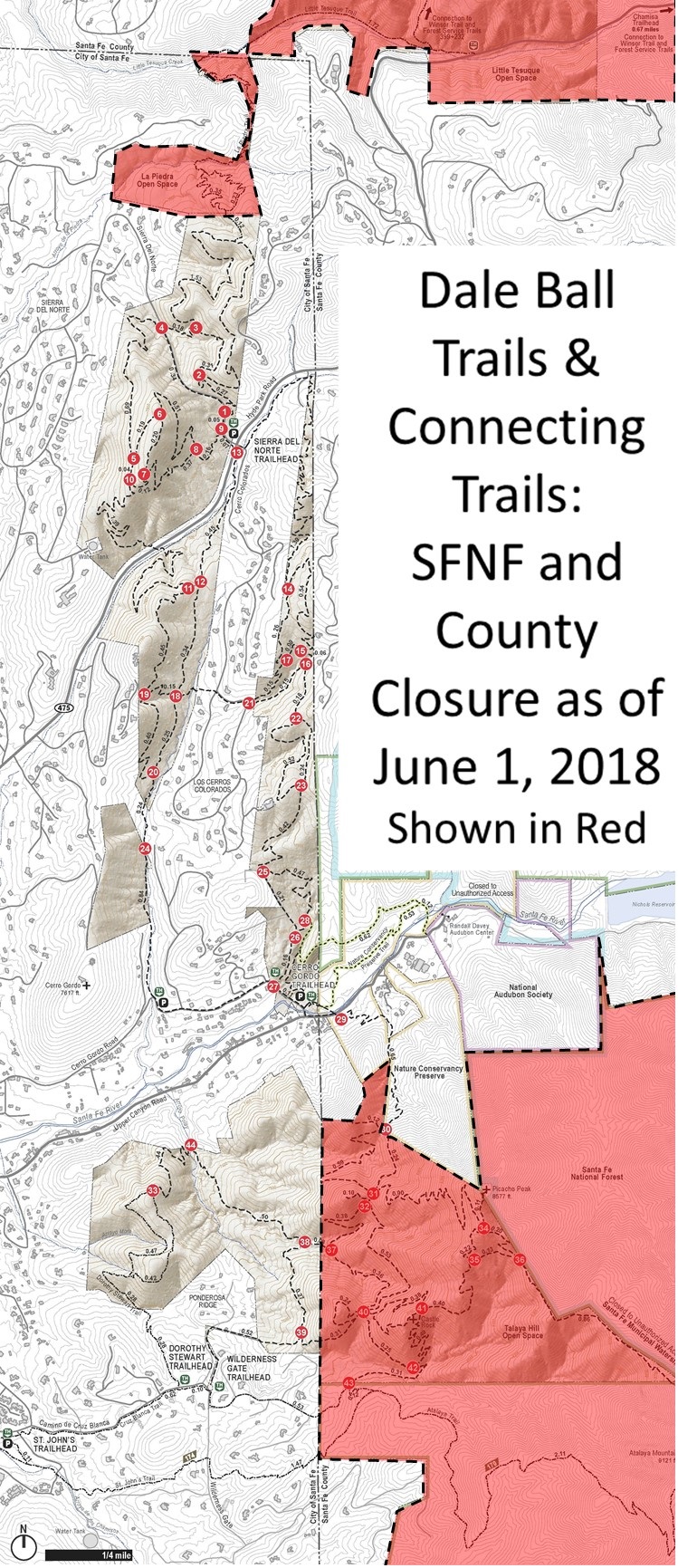
Trail map, lower Alamo Trail: Bandelier Natl Mnmt < https://www.strava.com/activities/2021098426 >

Related Posts:
 - Bandelier Celebrates 99 Years (Feb 2015)
 - Bandelier and Lummis Canyon (Apr 2012)
 - Frijoles Canyon in Recovery (Apr 2012)


Sunday, July 8, 2018

Where to Hike when New Mexico Forests are Closed?

The forests have been closed for the last 5 1/2 weeks due to extreme fire danger, though the Santa Fe National Forest plans to re-open tomorrow (July 9). The Carson National Forest and most of the Cibola National Forest districts have been closed as well. Where to hike and where to camp when all is shut down? Many hours were spent thinking through this problem and I reason it's a good tool for the next go around to share what I've found.

One of the premier underrated hiking trails in town is Canyon Road after sundown. No people, few cars, incredible back-lit windows framing rooms awash in color and artistry. Stop for a drink at the bar of your choosing before the return trip. Solitude, beauty, introspection - checks all the boxes. A more practical underrated trail for morning-folk is along the Santa Fe River from Delgado to Palace Ave. This route parallels Canyon a block to the north, is a true trail, and follows the river which often has at least some trace of water and murmuring current (present status: dry). At its mid-point the trail fords a rickety bridge-crossing to the new promenade along Alameda and a footpath will bring you back down along riverside. Stop at the Teahouse on Palace for coffee and pastry (available to go) then slow-walk back via trail or the morning gallery aesthetic on Canyon. We live in a nice town, it's a joy to take in this gem of a loop. Less creative alternatives are Arroyo Hondo and La Cieneguilla.

Where to camp? Those besides myself that were sifting available options surely realized this required deeper thinking, namely as to what land is managed by which public agency. Most state parks remained open through the closure, Hyde Park and Fenton Lake excepted. Cerrillos Hills and La Cieneguilla state parks are day-use only. Villanueva state park along the Pecos was on my tick list but availability was limited on weekends. All of the Caja del Rio was closed (National Forest). Chama river, closed (National Forest).

Mrs. Dirt, strolling riverside on the footpath
Bandelier backcountry and wilderness area were closed, though camping remained open at the Juniper and Ponderosa campgrounds. Much of the value of Ponderosa was limited in that the nearby Upper Crossing Trail was closed. BLM is federal land but managed by each state which meant that BLM remained open. Local BLM access includes Diablo Canyon where the camping at the few developed spots was open. Access to the nearby Rio Grande however was closed (National Forest). The Rio Grande Gorge and Rio Grande del Norte National Monument were the most extensive outdoor areas open during the closure (BLM). Wider afield, the wilderness areas west of Albuquerque remained open as did the Sabinoso wilderness east of Vegas. Pecos, San Pedro Parks, and Sandia wilderness areas were all shuttered for the reason that all three are within the boundaries of either the Santa Fe or Cibola National Forests.

My last note here really ought to reinforce the underlying point of all this: Don't use fire in the forests. Don't scavenge for wood, don't pack in logs, don't burn things when surrounded by thousands of acres of latent fuel. Campfires in the backcountry are unnecessary and harbor the potential for catastrophic damage to the forests and watersheds. Be a good steward, change your habits if you haven't already.


Related Posts:
 - The Borrego Fire: Nambe Creek - TR 160
 - Scouting New Mexico Running Trails by Plane
 - Santa Fe Forest Closed for Fire Season (c. 2013)
 - The Santa Fe River Trail


Monday, January 15, 2018

2018 New Mexico Outdoors Calendar

West Rim Trail
The calendar has flipped and the 2018 Event & Outdoors Calendar has now been brought up-to-date (see Tab at page top^). Most of the year's early season events have been pushed back in hopes of snow, we'll see if the storms are late to arrive or pass us by.

The U.S. Indoor Track & Field Championships is back for another go at the Abq Convention Center. Love this event so much. One season-changer finds the fledgling Outside Bike & Brew event here in Santa Fe jumping from May into early September.

Big additions to the calendar or events that have ceased operations? None that come directly to mind. Announcements or listings welcome at highdesertdirt at gmail dot com.


Related Posts:
 - 2018 Outdoors Calendar
 - 2017 Outdoors Calendar
 - 2016 Outdoors Calendar
 - 2015 Outdoors Calendar
 - 2013/2014 Outdoors Calendar

LinkWithin

Related Posts Plugin for WordPress, Blogger...