 |
| Trail scoutin' time |
One of my trail-running friends is a pilot and flight
instructor who happens to own a plane. Recently Mike had this genius idea that
we'd motor the plane above the foothills and scout some of the running trails
from the air. Sounded pretty good to me but it was much better than good. Certainly one of the finer ideas I've been a part of in awhile, and the following is what we saw.
We got out on a perfect New Mexico summer evening for sight seeing
and watching the sun chase the horizon. Fired up our little rocket and shot into the sky
Chuck Yeager style - albeit with a propeller in place of sonic jet engines. Our
initial flight path took us over
Casa Dirt and the new
trail underpass at St Francis Dr.,
then we headed out and over
Museum Hill, then east toward Thompson Peak
and the city reservoirs. This is a restricted area of the Santa Fe Watershed,
restricted to hikers and what-not, but not to planes - suckas! Pretty phenomenal
back there, the reservoirs were looking a bit low but the rains are now doing
their best to fill them back up.
 |
| The Sangre de Cristos viewed from the McClure reservoir |
 |
| Big Tesuque Creek and the Winsor Trail |
|
|
 |
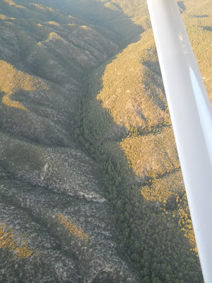
| The Pacheco Fire burn-scar and Santa Fe Baldy. Borrego Trail follows the drainage along the backside of the burned ridgeline at mid-photo. Upslope is green but the other half of the trail drainage is black. Erosion is undoubtedly a problem over that section of trail. |
 |
| Close up of the Pacheco Fire damage. SF Baldy towers above. |
 |
| Nambe Creek amid a charcoal forest. The Puerto Nambe saddle is clearly visible up canyon, SF Baldy (l), Lake Peak (r) |
 |
| Nambe Creek - A close-up of the silting and flooding damage. That's all ash, silt, and debris. |
From there, we headed north to gaze down on the
Dale Ball
and
Winsor Trails. We sort of circled around trying to get a good look at the
Piedra connector. We ventured higher and east-er to investigate the
Pacheco Fire burn scar from last year's fire season. A lot was burned crispy, a lot was
singed a little, and strangely there was some large areas that just seemed to
have been left alone. Flooding damage (from ash and erosion) in the upper Nambe
drainage there was pretty extensive. The section of Borrego Trail that runs from
Aspen Ranch to Nambe Creek was torched on one side but untouched and green on
the other. If I remember correctly this is where land managers believe the fire touched off. I need to get up there and check things out on foot.
The flight's true highlight (there were actually a
lot of highlights) was investigating a five-year old timber blowdown way
up in a remote section of the Pecos Wilderness. We found it up around
10,000ft just west of East Pecos Baldy, which is the second peak
north from
Santa Fe Baldy, south of the Truchas white-caps.
 |
| The forest blowdown, East Pecos Baldy in background |
 |
| View from above the ridge |
 |
| Finer detail - note the trees are just laid down whole |
 |
| Finer detail. Note that those are mature 40-60ft tall ponderosa pine trees. |
I had heard about the blowdown from an SFNF ranger (Miles Standish) but was not expecting to witness several square miles of giant ponderosas neatly fanned out on the ground like some odd Twilight Zone event. We circled around a bit to sort of absorb the scale of this madness, particularly in relation to the burn scars we'd just seen. We quickly concluded that had someone been on the ground when it happened there would have been no hope of survival - either you'd be dashed against a tree or rock, or crushed moments later, or perhaps both. Forest managers estimate a 100mph microburst of wind created this mess around the month of August, 2007. Capulin Trail 158 used to pass through the area but is now obliterated and will be abandoned.
Click through the map below to see detail of the blowdown event on Google satellite images.
View Santa Fe National Forest Blowdown - Pecos Wilderness in a larger map
Mike carts folks out and above town nearly every
day via hourly flying lessons. Skip the next obligatory gift of a tie for
Father's Day or the birthday tool set or whatever and opt for something way more awesome like a few hours in the skies
instead. Highly recommended.
 |
| Mike pilots through a banked turn - we removed the plane's doors for better viewing |
 |
| Yours truly at the controls (note the sweat-seasoned running hat). I appear tense because I'm trying not to land my friend's plane in a juniper tree |
 |
| Coming in low over Las Campanas. Sandia and Tetilla Peaks in the background |


Awesome. That blowdown is nuts. I got to fly from LAM (los alamos municiple) to TX with a co-worker a few years back. It is really cool seeing what you can see from a small plane.
ReplyDeletehttp://www.flickr.com/photos/targetsalad/sets/72157617150421955/
Nice, but bummer on all the fire destruction.
ReplyDeleteThat's really cool. I'm a tad jealous.
ReplyDeleteAwesome, Kevin! I certainly hope to fly one day above the trails.
ReplyDeleteMax
Agreed, exploring by plane is awesome. Pretty much fact. It was also cool, motoring around at 11000-12000ft without doors cooled things off a great bit.
ReplyDeleteTarik, you need to get up to that timber blowdown with your hoss-bike and cart some of that wood outta there. That would make for some killer photos. Blaec, you ought to make a trip down to NM one of these days and we'll go explore some of this stuff. Max, you ought to give Mike a call and setup your own tour then show me the photos of what you saw. I think it would be pretty sweet to tour up the canyons of the Rio and check out what's hiding in some of those remote areas.
Matt - The fire up there last summer was a bummer, but seeing as there were no homes or buildings up there it didn't seem overly destructive to finally burn through the years of fuel lying about all over the forest floor. A shame of course that it was human caused. Other parts of the Pecos Wilderness - like the backside of Penitente - are littered with downed trees and snags. I'm always hoping it doesn't catch a lightning strike but it will some day.
Hope everyone is getting after it this summer. Cheers. KB