 |
| Upper Falls, scoured of all sand and debris (Dale Coker) |
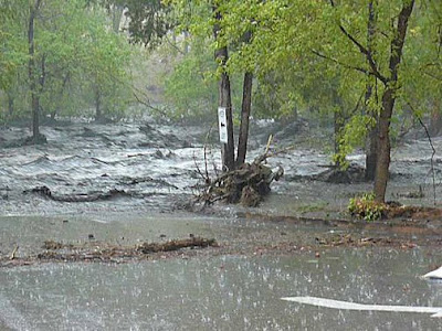
Last week's storms jacked things up seriously though, creating havoc not seen in recent
memory throughout the burn scars of the Los Conchas Fire and Pacheco Canyon Fire areas. Unusually strong storms coupled with the now denuded mesas and
canyons have produced flood images that defy rational imagination. Flood waters measured at between 3,000-4,000cfs rocketed down Frijoles
Canyon last Sunday
(8/21), with sizable but smaller runoff-fueled floods that Friday and Monday. Rainfall
on the mesas south of Los Alamos was measured at more than 2.5" in places. For comparison sake, we comfortably floated the San Juan river in Utah last month on 1,800cfs. The Bandelier
Monument Facebook page has been the best site to monitor the Los
Conchas Fire aftermath, restoration, and now the flooding. Sandbags, new jersey barriers,
plastic siding, and the removal of bridges inside the Monument helped to
minimize damage to the visitors area, although everything else was pummeled badly.
 |
| Frijoles Canyon at 3,000cfs. Note the flow has receded from high line indicated by debris (Tom Betts) |
 |
| Bandelier Visitors Center post-flood with several hundred displaced sandbags. Some of the concrete barriers were rolled and sheered from cable anchors. (Bandelier Facebook) |
 |
| Log jam up-canyon. Jams were spotted and cleared by Bandelier Rangers to minimize subsequent dam breaks and even more catastrophic flood damage (Bandelier Facebook) |
Just outside the west boundary of the Monument, the Cochiti
canyons funneled the same storms down into Lake Cochiti
with tragic effect. Dixon's
Apple Orchards were very nearly wiped away in entirety. In the video below one
can actually see a large canal that was bladed out along side the orchards to
divert expected monsoon floods away from the trees. That Sunday's flood looked
to be at least three times the worst-case anticipated volume. Very difficult to
watch destruction on that scale in a place so near to many peoples' hearts and
collective memories.
 |
| Dixon family home at the mouth of Medio Dia Canyon (Clyde Mueller/The New Mexican) |
The canyons of Santa Clara Pueblo up north saw similar
damage from the storms and are appealing for help.
To a
lesser but still serious extent, Nambe Pueblo and Nambe
Lake is seeing severe sediment and ash erosion into that area's main public water supply.
A bit of a downer post. Too much of a good thing (rain in the desert!) is sometimes bad, a cause-and-effect relationship you'd think a guy that runs to injury several times a year could relate to. It is the scale of this year's damage that makes these events difficult to accept. God speed to all the folks working to control the damage.
Related Posts:
Medio Dia Canyon (Cochiti) - 2/23/11
The Los Conchas Fire - 7/1/11
Pacheco Canyon and Los Conchas Forest Closures - 6/29/11
Related Posts:
Medio Dia Canyon (Cochiti) - 2/23/11
The Los Conchas Fire - 7/1/11
Pacheco Canyon and Los Conchas Forest Closures - 6/29/11
No comments:
Post a Comment