Showing posts with label Rain. Show all posts

Thursday, May 7, 2015

New Mexico Snowpack Melts Six Weeks Early

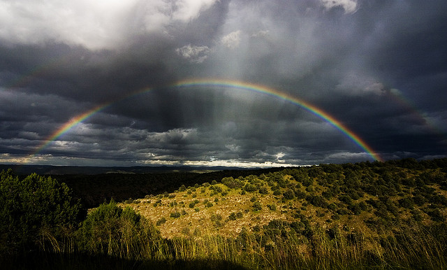
Atalaya in storm clouds
Beautiful rainy week in northern New Mexico. I love it when it's like this. Ever run in the foothills when you're literally ascending/descending through cloud banks? Bad AF. One time I was up there with clouds and fresh spring snow but the snow was saturated and melting and all the ravines and drainages were running and cascading like a Japanese garden. Top 5 all-time run that one.

So I was checking out the area river gauge data to get a sense of how much rainfall arrived this week, and I saw something unexpected that made me kinda grumpy. Yeah there's enough rain in this week's storms to bring the Rio up 500 cfs. But when you look at the 60 day graph you can see that the 44 year average (the yellow triangles) are showing that we ought to be at peak snowpack runoff right now. The blue line however shows that our snowpack burned off the last two weeks of March. Not cool. Beautiful weather we're having but June/July could be rough when our water is chilling down in Elephant Butte.


Here's the Santa Fe River data. Same story. No average trend line to compare but the melt in March is clear as day with a longer tail than the flow in the Rio. No mames buey.  


Related Posts:
 - RAIN - NM River Flows Spike to 30 Times Avg Flows (2013)
 - Snowpack at Santa Fe & Taos Fall Short (2014)
 - Arroyo Washout (2014)


Saturday, January 3, 2015

Another Year of Drought for Santa Fe - 2014

Santa Fe and surrounding areas had a terrific monsoon season this year, but as has been the case for much of the last decade our year-end precipitation totals fell well below the long term average. As measured at the airport, we ended 2014 with just more than 9.5" of rainfall/snowfall compared with the average of 13.5". Snowfall in the winter and spring months just hasn't kept pace.

Santa Fe Precipitation Chart - 2014
The chart above was provided by John Fleck, UNM water resources faculty and ABQ Journal contributor. John originally posted the precipitation chart for Albuquerque below, noting that it's the 7th consecutive year below average for the Albuquerque area.

Albuquerque Precipitation Chart - 2014

Related Posts:
 - Arroyo Washout (Oct. '14)
 - Frijoles Canyon in Recovery
 - River Gauges and Fall Floods

Friday, October 17, 2014

Arroyo Washout

Two foot+ drop in the arroyo floor at the St Francis Dr. crossing
My weekend run was along the Arroyo Chamiso. I'd seen in passing that the arroyo channel was destroyed near the house and I wanted to tour the rest of the carnage. Storms like the one that produced this flood happen every couple years but they're always a source of awe and excitement.

Massive scouring and drops in some areas; other areas collecting the tons of displaced sand resulting in rises of several feet. Debris in trees at levels above shoulder-height. Amazing stuff.

On the return trip I stumbled on two young graffiti artists in the culvert of the Old Pecos Trail crossing. They called me sir. I critiqued their work and ran on. Good kids.


Storm debris at the bridge along Gail Ryba suggests the flood level was above the bridge deck

Heavy debris (entire chamisa bushes) wrapped on railroad pylons up to 6ft in height

Helpful sign along Gail Ryba:  Don't enter the arroyo when flooding
An up-arroyo property armored with willow and cottonwood plantings. Erosion minimal.
A recent Dia de los Muertos themed piece near the museums


Related Posts:
 - RAIN! - NM River Levels Spike 30x Avg Flows (2013)
 - Come Hell or High Water - Monsoon Season (2013)
 - Floods Ravage Bandelier and Cochiti Canyons (2011)
 - Santa Fe's Arroyo Systems

Saturday, September 14, 2013

RAIN! - New Mexico River Levels Spike Upwards of 30 Times Average Flows

Lots of rain in New Mexico this week. How much? So much I can weed my yard without a trowel. A really cool novelty. Seriously though, it's so much rain that just about every drainage, rivulet, rito, creek, and river were bursting at the seams. Yay rain!

I don't have cool photos to post because my phone doesn't work well in the pouring rain, but I do have some cool graphs of the recorded water flows in the area via storm gauges. The information comes from the USGS water data website for New Mexico. Another great source to follow the storm has been Twitter, tag #nmwx (NM weather).

Here's the Santa Fe River (above the reservoirs). As can be seen the river has been running at a flow of 1.5 cubic feet per second (cfs) this Fall. The historical average for this time of year is 2.5cfs. Well, river discharge rocketed up to 170cfs last night and is at 140cfs as of Saturday morning. Up 100 fold. Think of the Rio Grande flowing through the gorge on the drive up to Taos. Near Embudo there the river has been running at around 250cfs the last several years. The Santa Fe Watershed approached that for a brief period last night.


Here's a view of the Rito Frijoles in Bandelier as a measure of the storm's intensity during the week. The Pajarito Plateau received rain in excess of 4" in places, half the year's average in a two day period. The canyon flashed from less than 1cfs to 1,000cfs. Four times the general flow of the Rio Grande near Embudo. That and the crests in the graph below are why Bandelier was closed yesterday and today.


A couple of images of just what 1,000cfs looks like in one of our little ritos, from the Bandelier Natl Monument Facebook page:

The Rito Frijoles near the visitors' center - Friday morning,  Sep. 13, 2013

The Frijoles wanders into visitor parking and the picnic area - Friday morning, Sep 13, 2013

And here's a view of what the Rio Grande looked like after all the arroyos and ritos and rios emptied their cargo into the mother drainage. From 250cfs to 9,000cfs yesterday near San Felipe. This is below the Cochiti dam. In other words, the pulse of water would have been much higher were not for the catchment below Santa Fe. A section of the Pecos River down near Roswell was gauged in excess of 30,000cfs on Wednesday morning. The highest measured flow on the Pecos since the 1930s. Now that, is no joke people.


Related Posts:
  - Frijoles Canyon in Recovery
  - Bandelier National Monument and Lummis Canyon
  - Santa Fe's Arroyos


Thursday, August 1, 2013

Come Hell or High Water - Monsoon Season

Hail piled a foot high at the office
August is here and July is past. It will be remembered as a month that brought weather that was juuust a bit north of the cray-cray. I will recreate some of it here.

It begins with severe drought conditions and a near statewide closure of the National Forests, then swiftly proceeds to be one of the wettest months in years. Then armageddon paid a visit to Casa Dirt around mid-month, bringing 1.25+ inches of rain cascading down in a twenty minute period. Along with the downpour came a hard driving blast of blueberry-sized hail which shredded all plant life. Hail cover accumulated on the ground like super-mean-spirited-hostile-snow before the rains melted it down and washed it away. Unexpected would be a fine way to describe it.

End result:  Rain barrels filled-over with water sitting mere feet away from a garden now torn asunder. A whole fence line of grape vines (and grapes), no mas. An entire plot of happy green chile plants reduced to stems with roots. Now if that ain't a step-back kick in the junk. I didn't cry, but it did get me thinking about how other men sometimes sob and cry and carry-on and that all sunk my spirits some. Then I remembered that there was some cold IPA in the fridge and that was that and now here's August.

Front porch geranium took one for the team. Sorry bro.

The St Francis underpass did not fair well. Took a day to
drain and dry then a crew from the City came in and swept it clean.

High water mark from the tunnel flood reached just above the crossbar of my bike. That's no joke. 

And some downstream video of the biblical event:

The Arroyo Chamisos in flood mode - near Camino Carlos Rey
Cray-cray

Related Posts:
  - Arroyo Chamiso Bike Underpass Nears Completion
  - More to Dirt than just Trails and Adventure


View Gail Ryba Trail - Santa Fe, NM in a larger map


Friday, July 13, 2012

Scouting New Mexico Running Trails by Plane

New Mexico Sport Aviation
Trail scoutin' time
One of my trail-running friends is a pilot and flight instructor who happens to own a plane. Recently Mike had this genius idea that we'd motor the plane above the foothills and scout some of the running trails from the air. Sounded pretty good to me but it was much better than good. Certainly one of the finer ideas I've been a part of in awhile, and the following is what we saw.

We got out on a perfect New Mexico summer evening for sight seeing and watching the sun chase the horizon. Fired up our little rocket and shot into the sky Chuck Yeager style - albeit with a propeller in place of sonic jet engines. Our initial flight path took us over Casa Dirt and the new trail underpass at St Francis Dr., then we headed out and over Museum Hill, then east toward Thompson Peak and the city reservoirs. This is a restricted area of the Santa Fe Watershed, restricted to hikers and what-not, but not to planes - suckas! Pretty phenomenal back there, the reservoirs were looking a bit low but the rains are now doing their best to fill them back up.

Sangre de Cristo Mountains
The Sangre de Cristos viewed from the McClure reservoir

Big Tesuque Winsor Trail
Big Tesuque Creek and the Winsor Trail


The Pacheco Fire burn-scar and Santa Fe Baldy. Borrego Trail follows the drainage along the backside of the burned ridgeline at mid-photo. Upslope is green but the other half of the trail drainage is black. Erosion is undoubtedly a problem over that section of trail.

Close up of the Pacheco Fire damage. SF Baldy towers above.


Puerto Nambe
Nambe Creek amid a charcoal forest. The Puerto Nambe saddle is clearly visible up canyon, SF Baldy (l), Lake Peak (r)

Nambe Creek - A close-up of the silting and flooding damage. That's all ash, silt, and debris.

From there, we headed north to gaze down on the Dale Ball and Winsor Trails. We sort of circled around trying to get a good look at the Piedra connector. We ventured higher and east-er to investigate the Pacheco Fire burn scar from last year's fire season. A lot was burned crispy, a lot was singed a little, and strangely there was some large areas that just seemed to have been left alone. Flooding damage (from ash and erosion) in the upper Nambe drainage there was pretty extensive. The section of Borrego Trail that runs from Aspen Ranch to Nambe Creek was torched on one side but untouched and green on the other. If I remember correctly this is where land managers believe the fire touched off. I need to get up there and check things out on foot.

The flight's true highlight (there were actually a lot of highlights) was investigating a five-year old timber blowdown way up in a remote section of the Pecos Wilderness. We found it up around 10,000ft just west of East Pecos Baldy, which is the second peak north from Santa Fe Baldy, south of the Truchas white-caps.

The forest blowdown, East Pecos Baldy in background

View from above the ridge
Finer detail - note the trees are just laid down whole

Finer detail. Note that those are mature 40-60ft tall ponderosa pine trees.

I had heard about the blowdown from an SFNF ranger (Miles Standish) but was not expecting to witness several square miles of giant ponderosas neatly fanned out on the ground like some odd Twilight Zone event. We circled around a bit to sort of absorb the scale of this madness, particularly in relation to the burn scars we'd just seen. We quickly concluded that had someone been on the ground when it happened there would have been no hope of survival - either you'd be dashed against a tree or rock, or crushed moments later, or perhaps both. Forest managers estimate a 100mph microburst of wind created this mess around the month of August, 2007. Capulin Trail 158 used to pass through the area but is now obliterated and will be abandoned.

Click through the map below to see detail of the blowdown event on Google satellite images. 


View Santa Fe National Forest Blowdown - Pecos Wilderness in a larger map


Mike carts folks out and above town nearly every day via hourly flying lessons. Skip the next obligatory gift of a tie for Father's Day or the birthday tool set or whatever and opt for something way more awesome like a few hours in the skies instead. Highly recommended. 

New Mexico Sport Aviation
Mike's flight shop


Mike Szczepanski Sport Aviation
Mike pilots through a banked turn - we removed the plane's doors for better viewing

New Mexico Sport Aviation
Yours truly at the controls (note the sweat-seasoned running hat). I appear tense because I'm trying not to land my friend's plane in a juniper tree

New Mexico Sport Aviation
Coming in low over Las Campanas. Sandia and Tetilla Peaks in the background


Friday, April 13, 2012

Frijoles Canyon in Recovery - Bandelier National Monument

Apparently the trails into the Bandelier backcountry are now open (with the exception of Falls Trail below Upper Falls due to a bridge washout). Los Alamos' Blake Wood toured Frijoles Canyon and the South Mesa last weekend to check out the damage from last year's fire and flooding. He photographed the somewhat frightening new landscape of the Frijoles Loop Trail (below).

The trail through Frijoles itself is mostly gone and the creekbed has been scoured several feet deeper in places. At least one location is blocked with enough debris to be only just passable. The section of canyon near the Visitor's Center appears to have been largely spared (from fire damage), but up canyon (6mi) near Upper Crossing the damage from fire and flooding is nearly total. Devastating in scope to the casual hiker or trail-runner, but perhaps a not-so-gentle reminder of the dual nature of both forests and canyons in particular. Forests burn and canyons flood.

All pictures courtesy of Blake Wood, thanks a bunch Blake. View the full album and comments here.

Forest burn at the Ponderosa Campground (Junction of 501 and Hwy 4)

The view up-canyon (toward the Valles Caldera) from the north switchbacks

The view looking south across Frijoles canyon. Pretty much everything is crispy

The Upper Crossing of Frijoles Canyon - once a beautiful piece of green forest floor with a clear creek running through. Pretty much obliterated at the moment. Hard to look at this one actually.

Looking back - the view of Frijoles from the south mesa rim. A bit of green toward Highway 4

On the south mesa. Lots of torched ponderosa

Blake reported that he saw evidence of previously hidden ruins and artifacts (shown here) uncovered by the blaze.

Descending back into Frijoles toward the Visitor's Center. Looks a lot better at this point in the canyon. You can see a bit of the cliff dwellings and pathways down on the left.

Climbing back up canyon, the looks of things aren't too bad near the Visitor's Center although the trail is mostly gone as are all the bridges.

Major debris pile built up against some of the un-burned tree stands. Gives an idea of the volume of water that came through the canyon with all the vegetation stripped away.

A new narrows along the canyon. This didn't use to be there, now it's an alarming big feature.

A view of the expanded creekbed. It used to flow in a fairly narrow settled-in channel. One can also view the scouring that has taken place - draw a visual line from just below the base of the tree to the cliff face.

More scouring through a tight section. There used to be an obvious and well-worn trail through here. Now only creek.


Old man pondy at the end of the line. I'd imagine there's several thousand acres of these fellas but this guy settled down over a piece of the trail. This looks to be near the F-Campground area.

A hollowed tree flagged by Rangers as a likely wind hazard

Nearing the Upper Crossing once again and the hike out. This area is just crushed. Hopefully the grasses and shrubs will hurry back and set some anchors for the rest of the area to stabilize. Careful hiking/running through these parts if you venture out to see things for yourself.


View Frijoles Canyon - Bandelier, NM in a larger map


LinkWithin

Related Posts Plugin for WordPress, Blogger...