Thursday, April 26, 2012

The Santa Fe River Trail

Santa Fe River Trail
Santa Fe River Trail - Alameda & St. Francis
What's old is new again. Last fall saw some serious rehabilitation of the Santa Fe River west of Camino Alire and Bicentennial Park. The city was constructing a couple new miles of the Santa Fe River Trail, one of five main alignments in the city's new urban trail system. The work included completing the trail section between Camino Alire and Frenchy's Field (along Agua Fria). An existing but intermittent dirt footpath was graded, widened, paved, benches and trailheads were put in, a bridge was installed, and the river bed itself was cleared, re-channeled, and armored in places against erosion. Toward the end of last year I steered a few of my runs through here to monitor progress and there were still major pieces awaiting completion.

Ah, but I trekked down there again this last weekend because of the city's annual water release from the reservoir - part of the 'living river' ordinance put in place last year. It's a wonderful thing to run or ride, or just generally pass the time along a flowing waterway. Particularly so for the Santa Fe River in which one seldom sees a flowing current. To my surprise, the new section of trail was complete - and there were all kinds of folks walking and running and riding along, enjoying the day. There were half-naked kids playing in the water, making excited kid noises, floating makeshift boats and engineering sand-and-cobble dams. And quite amazingly, there were hundreds, maybe a few thousand planted saplings all throughout the sandy new riverbed from Camino Alire to Frenchy's field. I almost couldn't believe what I was seeing. It must've taken dozens of people and hundreds of hours to have completed that work. It looked fantastic.

Santa Fe River Trail
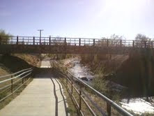
The underpass at Camino Alire

Santa Fe River Trail
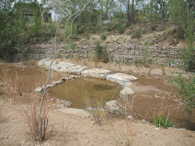
One of the many new pools, with current, sunbathing stones, and saplings of willow and cottonwood


Santa Fe River Trail
Willow saplings along the rehabilitated riverbed

Santa Fe River Trail
Looking south along the river. The new trail sits on the upper left


Santa Fe River Trail
(A crumby image) looking north from the pedestrian bridge. Water, the Sangres, and a soon to be forest of saplings

I wondered to myself how long it had been since the Santa Fe River had looked this grand. Fifty years? Sixty? Since the public works projects of the 30's? It's never resembled anything close to this in my lifetime and I'm closing in on forty.

Santa Fe River Trail
Footpath along the river, a few blocks north of Canyon Rd

The River Trail now stretches unbroken from Frenchy's Field to Delgado St east of downtown Santa Fe. One can navigate the rest of the way to Patrick Smith Park by sidewalk or by an un-maintained footpath along the riverway. The adventurous can wander further up the Access issues along privately maintained Camino Pequeno now require hikers/runners/bikers seeking to wander the little known Santa Fe River Preserve to seek public access from either Upper Canyon or Cerro Gordo (more below). On the western terminus, the county has completed a small stretch of the trail through Agua Fria Village and Camino Real Park, with plans to connect east to the newly completed city section, and eventually westto the Polo Grounds near the Santa Fe Airport.

Trail Update (7/3/14):  I have received notice of repeated trail conflicts on the Camino Pequeno lead-in to the SF River Preserve, and have been asked to clarify the trail through here. Residents tell me that the road itself and adjacent property are not a public thruway. It's unknown if there may be a public easement along the river itself, however, there is currently no formal trail alignment through here. These seem like good people that are increasingly frustrated about this problem. Please respect these folks' privacy and access the Preserve via Upper Canyon and/or Cerro Gordo.
I am a resident of Camino Pequeno - The road is a private way (clearly posted) and was not designed for public access. We wouldn't mind people enjoying the river, if they stayed along side it or traversed the other side, but people have started cutting through yards and congregating on the road which is both invasive to our privacy and in some cases has resulted in destruction of property. Having cyclists fly down it is not only hazardous in such a confined area, but it destroys the serenity for residents...Both Cerro Gordo and Upper Canyon Road have legal [public] places to park and provide open-access routes through the city easements and arroyos to the trails along the river. Thank you for being alert to the issue! I and the other residents appreciate it! Best Regards, D.B.

Related Posts:
Moon Mountain Trail
- Apache Canyon Trail Loop
- Acequia Trail Underpass - All Queued Up


View Santa Fe River Trail - Santa Fe, NM in a larger map

Friday, April 20, 2012

Additions to New Mexico's Wilderness Areas - The Columbine Hondo Wilderness Act


Columbine Hondo WSA
Outgoing Senator Jeff Bingaman announced earlier last week his intent to introduce congressional legislation that would designate the current Columbine Hondo Wilderness Study Area as permanently protected Wilderness. The 46,000 alpine expanse stretches between Taos Ski Valleyand Red River in the Carson National Forest, book-ended by the Wheeler Peak Wilderness to the south and the Latir Peak Wilderness to its north. Originally designated as a Wilderness Study Area in the New Mexico Wilderness Act of 1980, the status of the area's management purpose has been in limbo for the last 30yrs.

New wilderness and permanent protection of roadless areas is a good thing, definitely something I can get behind. In practice however, none of this is going to create a noticeable change in the character of the area as it is now or as it has been since 1980. The real kicker to the proposed legislation is the following - in addition to the possible new wilderness protections, the legislation would also designate a portion of the land as a National Recreation Area to allow for the preservation of existing bike trails in the East Fork/Middle Fork area and for the added purpose of constructing a new backcountry trail that would connect the trails in and around Taos Ski Valley to the system of trails in Red River. Managers of the Carson National Forest have already committed to working with folks in the cycling community to get this done. Now that is badass, and it creates a clear blueprint for the groups in Santa Fe pushing for an expansion of the Pecos Wilderness into the Tesuque Creek Watershed and those that want to preserve mountain bike access to all the trails that would encompass, mainly the Winsor Trail network. The Santa Fe Fat TireSociety sprang to life in early 2011 for this specific purpose. 


The grass-roots coalition responsible for cobbling together the Columbine-Hondo legislation and moving it onto the Senator's desk include a broad based collection of area residents, sportsmen, conservationists, and a joint effort from the Taos Cycling Coalition, the Santa Fe Fat Tire Society, the IMBA and the Carson National Forest. All of these groups deserve substantial recognition and the full support of the northern New Mexico outdoors community.

Update (Dec.2014): The legislation passes and heads to the Pres for his signature

Related Posts:
 - End of Year Charitable Giving
 - Drink Beer - Support Local Trails
 - Wheeler Peak - Taos, NM


Thursday, April 19, 2012

Dos Ciclos

Ran across this cool video-short in the archives at Outside. It takes a brief but fascinating look at cycling culture in Mexico City. The direction and narration are greater than the riding itself but together it makes me want to travel somewhere far away and just ride, and ride, and ride..


Created and directed by Rodrigo de la Mora and Dario Lopez Ortega for the International Bicycle Film Festival, cycling by Alfredo Espinosa, music by De Panoptica Orchestra 'Pico Selector'.

The looming peak in the video's first frame is Iztacciuatl just outside Mexico City. It's one of two 17,000ft glaciated volcanoes that frame the giant city. The other is Popocatepetl which regularly emits ominous plumes of smoke. If you should visit Mexico City these awesome mountains will sear their image to memory.

Monday, April 16, 2012

Boston!


Boston Marathon Finish
The finish on Boylston St and Copley Square
Today is Patriot's Day which can mean only one glorious thing - Folks are lining up on the streets of Hopkinton Mass. for the 116th running of the Boston Marathon. And the world is good.

The weathermen are cautioning runners for unusually warm temperatures. Folks will just have to run within themselves, adjust their efforts, and nail it down. It's a marathon after all, not some piffy soccer game.

Not a lot of top Americans running today on account that they all competed in the Olympic Trails Marathon in January. The men's defending champion and record holder Geoffrey Mutai is in the field. The man's racing skills are not human. In the women's field Santa Fe's Caroline Rotich lines up again after a 4th place finish in last year's race. Best of luck to her.

A few Santa Fe area runners have done the qualifying work and will be running down to Boylston St. today. One of my training buddies James Nunez will be out there for a second Boston, the indomitable Maryann Kos is there, as will Rose Giannotta for her first run along the storied course. Other Santa Fe qualifiers include Amanda Cola, Kelly Cyr, Andy Winnegar, and Katrin Silva of Las Vegas. Athletes can be tracked during the race at the BAA website here. If I'm missing someone please add them in the comments below. Wave starts begin at 10am ET.

Desi Davila Boston Marathon
Last year's women's elite field mid-race. The lone runner 50m back is Michigan's Desi Davila. An unknown before the race, she stormed back to take the lead a few hundred meters from the finish on Boylston St. before submitting to a late surge from the eventual winner. She's now an Olympian with a spot locked up for London Games.

UPDATE: Un-seasonal heat controlled the field this year, causing many of the elites to drop after 25km including defending champ Geoffrey Mutai and Santa Fe's Caroline Rotich. The race was won with a savvy performance from former Univ. of Louisville runner Wesley Korir in 2hr 12min. In favorable weather last year's winning time was 9min faster, nearly 2 miles of distance at the pace the elites maintain. He bided his time stalking the leaders and was fortunate to time his drive home when the front runners all broke from the heat. Kenya's Sharon Cherop faded on Boylston St last year but learned from her mistakes to capture this year's crown after holding off a surge on the same spot, winning in 2hr 31min.

The field of Santa Fe runners made the best of it but athlete tracking showed a monumental struggle with pacing after 15km. For the third straight year Albuquerque's Mark Scherbarth posted the fastest time of all New Mexico amateurs with a 3:03:20, almost 20min slower than 2011. Santa Fe results include Maryann Kos, 3:52:27; Kelly Cyr, 4:02:13; James Nunez, 4:02:21; Max Mujynya, 4:25:21; and Rose Giannotta, 4:49:19.

Friday, April 13, 2012

Frijoles Canyon in Recovery - Bandelier National Monument

Apparently the trails into the Bandelier backcountry are now open (with the exception of Falls Trail below Upper Falls due to a bridge washout). Los Alamos' Blake Wood toured Frijoles Canyon and the South Mesa last weekend to check out the damage from last year's fire and flooding. He photographed the somewhat frightening new landscape of the Frijoles Loop Trail (below).

The trail through Frijoles itself is mostly gone and the creekbed has been scoured several feet deeper in places. At least one location is blocked with enough debris to be only just passable. The section of canyon near the Visitor's Center appears to have been largely spared (from fire damage), but up canyon (6mi) near Upper Crossing the damage from fire and flooding is nearly total. Devastating in scope to the casual hiker or trail-runner, but perhaps a not-so-gentle reminder of the dual nature of both forests and canyons in particular. Forests burn and canyons flood.

All pictures courtesy of Blake Wood, thanks a bunch Blake. View the full album and comments here.

Forest burn at the Ponderosa Campground (Junction of 501 and Hwy 4)

The view up-canyon (toward the Valles Caldera) from the north switchbacks

The view looking south across Frijoles canyon. Pretty much everything is crispy

The Upper Crossing of Frijoles Canyon - once a beautiful piece of green forest floor with a clear creek running through. Pretty much obliterated at the moment. Hard to look at this one actually.

Looking back - the view of Frijoles from the south mesa rim. A bit of green toward Highway 4

On the south mesa. Lots of torched ponderosa

Blake reported that he saw evidence of previously hidden ruins and artifacts (shown here) uncovered by the blaze.

Descending back into Frijoles toward the Visitor's Center. Looks a lot better at this point in the canyon. You can see a bit of the cliff dwellings and pathways down on the left.

Climbing back up canyon, the looks of things aren't too bad near the Visitor's Center although the trail is mostly gone as are all the bridges.

Major debris pile built up against some of the un-burned tree stands. Gives an idea of the volume of water that came through the canyon with all the vegetation stripped away.

A new narrows along the canyon. This didn't use to be there, now it's an alarming big feature.

A view of the expanded creekbed. It used to flow in a fairly narrow settled-in channel. One can also view the scouring that has taken place - draw a visual line from just below the base of the tree to the cliff face.

More scouring through a tight section. There used to be an obvious and well-worn trail through here. Now only creek.


Old man pondy at the end of the line. I'd imagine there's several thousand acres of these fellas but this guy settled down over a piece of the trail. This looks to be near the F-Campground area.

A hollowed tree flagged by Rangers as a likely wind hazard

Nearing the Upper Crossing once again and the hike out. This area is just crushed. Hopefully the grasses and shrubs will hurry back and set some anchors for the rest of the area to stabilize. Careful hiking/running through these parts if you venture out to see things for yourself.


View Frijoles Canyon - Bandelier, NM in a larger map


Tuesday, April 10, 2012

Bandelier National Monument and Lummis Canyon


Adolph Bandelier c. 1880 - courtesy Museum of NM
Local historian Mark Simmons penned a terrific write-up of area icon and archeologist Adolph Bandelier in his most recent column in the Santa Fe New Mexican. Bandelier is a New Mexico figure I have a lot of admiration for if only because of my many wanderings through the canyons and mesa tops of his namesake at Bandelier National Monument. Even in the wonderland of northern New Mexico, the canyons of Bandelier are a special place to visit. As usual, Simmons frames a compelling historical profile that is worth a read if you have a few minutes to spare.

Bandelier came to New Mexico to survey and document many of the area's living pueblos at the turn of the century, but was eventually drawn to the ruins among the canyons of Los Alamitos upriver from Cochiti, proclaiming it to be 'the grandest thing I ever saw'. Simmons' write-up includes a bit about the archeologist's chance meeting and subsequent friendship with another New Mexico luminary, photographer Charles Lummis. Of their chance meeting, Bandelier writes:
"One day in a New Mexico sandstorm, a bronzed, middle-aged man, dusty but unweary from his 65-mile tramp from Zuni, walked into my solitary camp at Los Alamitos. Within the afternoon, I knew that here was the most extraordinary mind I had ever met."
Charles F. Lummis - courtesy of braunlibrary
Lummis was to travel extensively through the western Americas, spending a number of years in northern New Mexico, and later in his career he personally counseled President Teddy Roosevelt on the affairs of the Native Peoples of the western United States, acting as a staunch advocate for their cause. Together, Bandelier and Lummis archived and photographed much of the remaining artifacts and cliff dwellings of the people that once settled in and around the area of Frijoles Canyon. 

Established as National Monument in 1916, it was Bandelier's name selected by the Park Service to represent the area's cultural treasure in honor of the body of work the two men put together. Lummis' name adorns the magnificent canyon that stretches just west of Frijoles and Alamos canyons inside the Monument boundaries. The canyon's elevation profile dips 700ft from rim-to-floor. A spectacular sight and a trail obstacle with few rivals. 

There's a fairly extensive network of trails through Bandelier Monument that cross the mesas and send the canyons. The origins of some may be as old as the ancient cliff dwellings themselves. The loop through Frijoles Canyon (16+mi) might be the best trail run in northern New Mexico in my opinion. At the present time much of the backcountry trail network is closed due to the catastrophic damage from last summer's Las Conchas Fire. When the restoration work begins to fall into place and the trails open to the public once again it is well worth the time to run out Frijoles or venture out to Lummis Canyon and the Stone Lions beyond.

Frijoles Canyon looking west (c. 2008)  - courtesy of mywisconsinspace.com
Stone Lions, Bandelier Natl Mon. - HDD (Aug, 2009)


View Frijoles Canyon - Bandelier, NM in a larger map


Wednesday, April 4, 2012

Atalaya Mountain and Spring Snowstorms

sun mountain snow
St John's College and Sun Mountain and snow
Distance: 7mi roundtrip
Starting elev at St John's College TH: 7300ft
Atalaya Summit: 9121ft
Atalaya: (Sp) for 'Watchtower', which is badass in of itself

The three weeks of Spring weather that we had enjoyed of late was firmly pushed aside Monday by a terrific blast of winter. New Mexico is awesome. I might as well be living in Disneyland.

From the office desk I watched in wide-eyed silence as the gloom outside spread and grew dark and big gobs of snow finally began falling from the heavens. Given those circumstances there is really only one appropriate action to take  - and that's to race home, grab the running shoes (and hat and gloves), and dash off to the hills for an epic snow-trail run. And that's what I did.

Trees in bloom with spring snow

chamisa winter snow
Frosted chamisas along the arroyo
santa fe winter snow
Looking down valley from Wilderness Gate Rd

juniper winter snow
Snowy juniper

atalaya mountain winter snow
At the (national) forest gate - one mile in

My preference in running-trails when the weather socks-in is Atalaya. The gains in altitude amplify the snow and cloud for maximum effect. Not a lot of traffic out there Monday night unless you count the ponderosa and cedar. They looked as psyched as I was, pantomiming low sweeping tree-branch hi-fives to each other. 

atalaya mountain winter snow
The baby ponderosa grove at the third switchback

atalaya mountain winter snow
Spring running trail

ponderosa tree winter snow
Crazy hi-fiving ponderosa

santa fe foothills winter
The foothills in snow
santa fe foothills snow
Dry ledge with handy moss rocks

atalaya mountain winter snow
Atalaya finally comes into view

Near zero visibility at the top. I know there was a sunset out there somewhere, but the view of ridgelines receding into stormcloud was pretty impressive all the same. The weather picked up and I headed back. Descended in the dark. Didn't see a soul for 90min+, coming or going, on one of the best days on Atalaya we'll have all year.

atalaya mountain winter snow
Atalaya summit

atalaya mountain winter snow
South ridge of Atalaya in cloud (and sunset)

Somewhere Christmas-y and wonderful

national forest sign snow
Back at the trailhead

I've made the summit in 43min before. Add approximately 7min if your plans include hi-fiving trees, heckling the crows, and walking a few of the steeps.1hr+ for hikers (one-way)

A looped hike is possible off the north ridge down the saddle to Picacho Peak, then descending portions of the Dorothy Stewart Trail back to Camino Cruz Blanca or St. John's. Approximate mileage for this link-up is 8mi+.

Nearby Trails:

Sunday, April 1, 2012

Micah True - A Life Well Lived


Micah True - curtesy of RunTramp.com
The dominant news story in the running world this weekend is the passing of trail running icon Micah True. Also known as Caballo Blanco in the Mexican villages where he ran out thousands of miles, True was a passionate advocate for the Tarahumara Indians of Mexico's Copper Canyon. He brought attention to their plight as the race director for the Copper Canyon Ultra Marathon, run each March in Urique, Mexico. True was elevated to trail icon status from his prominent depiction in Chris McDougall's influential trail bible Born to Run (c. 2009).

I thought I might not write about Micah's passing because I haven't read McDougall's book and I didn't know the man myself, but several area runners did, (Gabe, Mariam, Ruthanne, Daniel, Marc). Many had made the trip down to Urique to meet the legend and the quiet people for whom he advocated, and to run the trails that he made famous. Others had met him or heard him speak at trail and mountain events around the southwest over the last couple years. He was very well liked and highly respected. It was this network of people who held him in such high regard that first brought media attention to his disappearance near Silver City earlier last week, and it was the same mass of well-wishers that drove the growing media attention as large search parties formed to aid in the rescue effort. For an athlete in a very niche, non-commercial sport, the bright spotlight that his passing has attracted is an impressive testament to what kind of a man he was and what kind of effect he inspired in others. 

In the canyons of Mexico - curtesy of Ryan Heffernan
  
Coverage of his passing in the Boulder Daily Camera can be found here.
Notable acknowledgments to the man in the blogosphere can be found here, here, and here.
A photo album of the Copper Canyon Ultra can be found here (Outside Magazine)

LinkWithin

Related Posts Plugin for WordPress, Blogger...