Showing posts with label Summits. Show all posts

Friday, April 22, 2016

Plaza2Peak - Sun April 24th

This year's 2nd Annual Plaza2Peak event has been organized for this Sunday morning (4/24), 830am. If you haven't been receiving the emails all Race Director details are below:

Inaugural start - Santa Fe Plaza
Plaza2Peak is Santa Fe's best race. It was started in 2015 after Maddawg found the idea in the bottom of a bottomless marg. Starting with a hot lap around the plaza, toping out over 12,000', and finishing with an SEC-style tailgate, it is the only way to spend a gale-force spring day. 


0) There will be a $15 entry fee to help cover the cost of the tailgate and ~prizes~. Find me on venmo @Madeleine-Carey or bring cash day of.

1) Race will start at 9 AM SHARP from the plaza.

2) The "ski" will go to the summit of Deception, not to the sign in the saddle that says Tesuque (not the Towers, not the top of the chairlift). Descend to parking lot for event tail-gater. 

3) Racers may either run or bike, no combined division. Michael Dax will be the first and the only champion of that division. 

4) There will be no requirement to carry your skis on your bike. 

5) If you carry your skis on your bike, you will be awarded a handicap. Contact Bryan Rogala for help attaching your skis to your bike.

Bryan - pioneer of awesome
6) Pre-race meeting/briefing and ski drop at the Fort Marcy Parking Lot. Look for the big white truck. EVERYONE MUST BE THERE!!

7) Wear a helmet on your bike
    wear a helmet on your skis
    wear a helmet when you hike
    wear a helmet at all times please! 

8) I will send a detailed email on April 21st so if you ask a question, I will answer it on that day. Unless you want to sponsor this, then ask away!

9) Forward away!!! 

Plaza2Peak - 2015

Related Posts:
 - Candide Thovex - Freesking the French Alps
 - Santa Fe's New Ski Shuttle
 - Santa Fe's First Snow of the 2015 Season - Oct 21.15

Friday, March 20, 2015

Plaza2Peak - Sat. April 11th

Daybreak at the top of the Triple Chair - Towers just beyond
One of our local hard-chargers has developed the brilliant idea of a DIY enduro race from the Plaza to Tesuque Peak. Run or Bike to the ski area, then skin or ski to the Towers, and finish back down at the parking lot for the post-race bash and casual apres-ski. More importantly, Mady has pulled together plans, a date, entry forms, and multiple emails encouraging friends to promote the genius mountain foray.

Loosely organized last December the tentative date for Plaza2Peak is now set for Sunday Saturday April 11th, 10am start. A date that may even work for harried tax accountants.

Many of us talk of setting something up like this. Several of us have even sent town-to-towers in one form or another (running from the Tesuque trailhead off CR 72A to the Towers via Winsor is about 13mi, takes about 3hrs), but it's rad that someone has added organization to an interesting idea that usually goes solo or in isolated groups of two or three. Katie Arnold moved this type of idea forward several years ago with the Dale Ball Buster.
Moar Plz!

Entry forms can be found here:
http://tinyurl.com/kkchax7

Race Director-provided motivational training video here:


Related Posts:
 - Freeskiing the French Alps (extra motivational)
 - Taos Ski Valley Bought Up by Hedge-Funder
 - Ski Touring Deception Peak

Sunday, February 10, 2013

Early Morning on the Atalaya Trails

Adam and Hadji at the crest


Distance:  5mi.roundtrip
Elevation Gain: 1,600ft
Summit:  9,121ft
Time:  37min up, 19min down

A quick summit of Atalaya yesterday morning before the storms came through. Plenty of snow along the north ridge leading down to Picacho. I was with friends Adam and Hadji who towed me up when I cracked after the first steep section. I made the second mistake of wearing an ultralight shoe, not so good on the ice and steeper descents. Didn't see a single hiker, so we had all the blue vistas to ourselves.


Summit views of the city to the west - Atalaya Mtn 830am


Views off the north ridge, north foothills and the Dale Ball Trail layout below

View of town on the upper descent. The Jemez beyond are washed out from the light contrasts.

Our route ascended the main trail from the Atalaya trailhead, orange at first then blue below. We descended along green then an unmarked section between Picacho and Atalaya on the return.


View Atalaya Mountain Trail - Santa Fe, NM in a larger map


Wednesday, November 28, 2012

Sun Mountain Loop - Santa Fe, NM


Distance: 5.5mi roundtrip
Starting Elevation: 7,000ft
Summit Elevation: 7,920ft
Total Elev Gain: 1,400ft
Run time: 65min

Earlier this summer the city finally formalized hiking access to Sun Mountain. The trails have been there as long as I can remember, there was just never any central trailhead. Folks would set out from St. John's College or other informal waypoints and, as with many of the older trails around town, you just had to know from memory that a trail spur started behind that fence post, or that pinon, or up the driveway 40ft then veer left. New homes in the area over the last twenty five years have also closed off some sections of north-south trail that used to connect to the Arroyo Chamisos. In a fairly publicized development dispute a couple years ago, the Save Sun Mountain campaign came about, and donated money was rounded up to buy the last parcel of undeveloped land off the mountain's west slope which was then placed in trust for public access. The trailhead was mostly built out last summer, then left fenced off and unopened from what I could only guess was a reaction to the dangers of an incredibly destructive fire-season. The city finally opened it all up earlier this summer and it now gets a fair amount of traffic, particularly before sunset.

The new public easement and trailhead

I've yet to see a map of the existing trails on and around the mountain, particularly off the northside of Sun Mountain where access to St. John's College is a mess of unimproved trail, cairns to nowhere, spiderwebs of bullshit, and deadend ravines and drainages. The one well defined thru-trail heads away from St. John's, into the saddle with Moon Mountain, then east into the Arroyo Chamisos at the foot of Atalaya. It's marked decently with cairns but can be difficult to follow at dusk.

From the summit: Moon mountain at right, rising moon at top left, south Atalaya ridge at center

After poking around these these trails and hills over the last few weeks I finally mapped out the best existing loop during a run with Hoskisson over the Thanksgiving weekend. Beginning from Museum Hill the full loop is just short of six miles, the section of climbing is a bit less than one mile (trailhead-to-summit) with about 800ft of climbing.

We made the summit in 28min from the Cristobal Lane trailhead (Note: the area at Conejo Rd and Calle de Leon is fire lane access only. Neighbors have asked me to make clear this is not a trailhead nor open to parking; use the Cristobal or Cam. Corrales trailheads), running the loop counter-clockwise. 65min to run out the full loop. Sections of the climb are scrambling-steep and not rideable by bike.

Nearby Trails:
  - Atalaya Mountain
  - Dorothy Stewart Ridgeline
  - Upper Arroyo Chamisos &  East Foothill Trails
  - Moon Mountain


View Sun Mountain Trail Loop - Santa Fe, NM in a larger map


Friday, September 7, 2012

Big Tesuque Trail Run is on the Horizon


A few of the iconic area trail runs passed me by in the month of August. Both the La Luz Trail Run and the Pikes Peak Marathon and Ascent seemed to scream right by when I wasn't looking. Taos' growing trail event, the Up & Over Trail Run passed as well. Imogene Pass is tomorrow.

All of this means that Santa Fe's premiere trail run - The Big Tesuque Trail Run - is just four weeks away. Saturday Oct. 6th to be precise. This year will be the 28th iteration of the venerable event. Race director Peter Fant has all the mechanics of organizing in motion, and expects another beautiful Fall morning with coffee, breakfast burritos, prizes and raffle, as well as a field of the finest high altitude trail runners in the area. So if you haven't registered just yet, mark it on your calendar and start running laps on Atalaya to bring those climbing legs into form.

Results from past events are slowly being compiled and presented on the new Big T webpage. Similarly the page includes links to registration, a course map, details of the race's gracious sponsors, and links to past photo albums. Yes, I may have had a hand in all of this. Twenty-eight years of history add substantial value to an event, and when gathered up in one place, the weight of it all carries a bit of glory to all of the runners who have challenged themselves on the course through the years. 

big tesuque run aspens
An overcast morning on Big Tesuque in 2008 - photo by Max Mujynya


View Aspen Vista Trail (Big Tesuque Trail), Santa Fe, NM in a larger map


Friday, July 13, 2012

Scouting New Mexico Running Trails by Plane

New Mexico Sport Aviation
Trail scoutin' time
One of my trail-running friends is a pilot and flight instructor who happens to own a plane. Recently Mike had this genius idea that we'd motor the plane above the foothills and scout some of the running trails from the air. Sounded pretty good to me but it was much better than good. Certainly one of the finer ideas I've been a part of in awhile, and the following is what we saw.

We got out on a perfect New Mexico summer evening for sight seeing and watching the sun chase the horizon. Fired up our little rocket and shot into the sky Chuck Yeager style - albeit with a propeller in place of sonic jet engines. Our initial flight path took us over Casa Dirt and the new trail underpass at St Francis Dr., then we headed out and over Museum Hill, then east toward Thompson Peak and the city reservoirs. This is a restricted area of the Santa Fe Watershed, restricted to hikers and what-not, but not to planes - suckas! Pretty phenomenal back there, the reservoirs were looking a bit low but the rains are now doing their best to fill them back up.

Sangre de Cristo Mountains
The Sangre de Cristos viewed from the McClure reservoir

Big Tesuque Winsor Trail
Big Tesuque Creek and the Winsor Trail


The Pacheco Fire burn-scar and Santa Fe Baldy. Borrego Trail follows the drainage along the backside of the burned ridgeline at mid-photo. Upslope is green but the other half of the trail drainage is black. Erosion is undoubtedly a problem over that section of trail.

Close up of the Pacheco Fire damage. SF Baldy towers above.


Puerto Nambe
Nambe Creek amid a charcoal forest. The Puerto Nambe saddle is clearly visible up canyon, SF Baldy (l), Lake Peak (r)

Nambe Creek - A close-up of the silting and flooding damage. That's all ash, silt, and debris.

From there, we headed north to gaze down on the Dale Ball and Winsor Trails. We sort of circled around trying to get a good look at the Piedra connector. We ventured higher and east-er to investigate the Pacheco Fire burn scar from last year's fire season. A lot was burned crispy, a lot was singed a little, and strangely there was some large areas that just seemed to have been left alone. Flooding damage (from ash and erosion) in the upper Nambe drainage there was pretty extensive. The section of Borrego Trail that runs from Aspen Ranch to Nambe Creek was torched on one side but untouched and green on the other. If I remember correctly this is where land managers believe the fire touched off. I need to get up there and check things out on foot.

The flight's true highlight (there were actually a lot of highlights) was investigating a five-year old timber blowdown way up in a remote section of the Pecos Wilderness. We found it up around 10,000ft just west of East Pecos Baldy, which is the second peak north from Santa Fe Baldy, south of the Truchas white-caps.

The forest blowdown, East Pecos Baldy in background

View from above the ridge
Finer detail - note the trees are just laid down whole

Finer detail. Note that those are mature 40-60ft tall ponderosa pine trees.

I had heard about the blowdown from an SFNF ranger (Miles Standish) but was not expecting to witness several square miles of giant ponderosas neatly fanned out on the ground like some odd Twilight Zone event. We circled around a bit to sort of absorb the scale of this madness, particularly in relation to the burn scars we'd just seen. We quickly concluded that had someone been on the ground when it happened there would have been no hope of survival - either you'd be dashed against a tree or rock, or crushed moments later, or perhaps both. Forest managers estimate a 100mph microburst of wind created this mess around the month of August, 2007. Capulin Trail 158 used to pass through the area but is now obliterated and will be abandoned.

Click through the map below to see detail of the blowdown event on Google satellite images. 


View Santa Fe National Forest Blowdown - Pecos Wilderness in a larger map


Mike carts folks out and above town nearly every day via hourly flying lessons. Skip the next obligatory gift of a tie for Father's Day or the birthday tool set or whatever and opt for something way more awesome like a few hours in the skies instead. Highly recommended. 

New Mexico Sport Aviation
Mike's flight shop


Mike Szczepanski Sport Aviation
Mike pilots through a banked turn - we removed the plane's doors for better viewing

New Mexico Sport Aviation
Yours truly at the controls (note the sweat-seasoned running hat). I appear tense because I'm trying not to land my friend's plane in a juniper tree

New Mexico Sport Aviation
Coming in low over Las Campanas. Sandia and Tetilla Peaks in the background


Sunday, June 3, 2012

Trail Running Santa Fe Baldy and the Three Peaks

SF Baldy (L), Penitente and Lake Peaks (center-L), Tesuque Pk (center)
A reader sent over a listing of top performances for a few of the northern New Mexico summit trail runs. The listing comes from the MTN RNR trail running series, an informal group of local backcountry runners that get together to run-out these established courses on an annual basis and have been keeping records of best performances going back to the 1980’s.

The recognized Three Peaks route begins at the Santa Fe Ski Basin (10,000ft), heads up Winsor Trail to the summit of Santa Fe Baldy (12,622ft), descends south and passes through the Puerto Nambe saddle over to Penitente Peak (12,160ft), then up the east ridge of Lake Peak (12,409ft), traversing minor highpoint Deception Peak and just below the radio towers on Tesuque Peak (12,000ft), down Aspen Vista Rd to the trailhead, then a brief climb up Hyde Park Rd to the starting point. Roundtrip distance is 18.7mi with 4,550ft of climbing.

Best recorded performances of the Three Peaks route are the following:
 (M) Record:  Leo (Senovio) Torres – Cordova, NM, 2hrs 56min 56sec (1992)
 (W) Record:  Katie Gengler – 3:46:00 (1998)
 (M) Masters:  Leo (Senovio) Torres – 3:19:55 (1995)
 (W) Masters:  Ginny LaForme – 4:26:59 (1995)

Santa Fe Baldy (L), Deception Peak (near), Lake Peak (R)
Rumor has it that the late Russian alpinist Anatoli Boukreev may have challenged or bettered Torres’ record during one of his Santa Fe training sessions, but I haven’t heard enough detail to substantiate more than a mention in passing here.

Regardless, that is smokin' fast. I've run to Baldy summit in around 1hr 30min. Now that's not time-trialing but even if you take that down 15min you still need to add the traverse to Penitente and Lake Peaks (~1hr), the descent to Aspen Vista trailhead (I've raced down in 35min which isn't superfast but top speed for myself), then another 10min climb to the car. So my fastest possible times all linked together would still be short by 15-20min of Torres' best. The guy is a legend and deservedly so.

I’ve received a couple other emails regarding area records and performance lists and have added them to the updated New Mexico Records page along with the times above. The Tough Guy page has also been updated with a few runner profiles from the Four Minute Milers list. Good reading.

Related Links
- Santa Fe Area Trails List
- Santa Fe Peaks and Summits


View Deception Peak - Santa Fe in a larger map


Friday, February 24, 2012

Wheeler Peak, Taos NM


Wheeler Peak New Mexico
Wheeler Peak, the far high point, New Years 2012
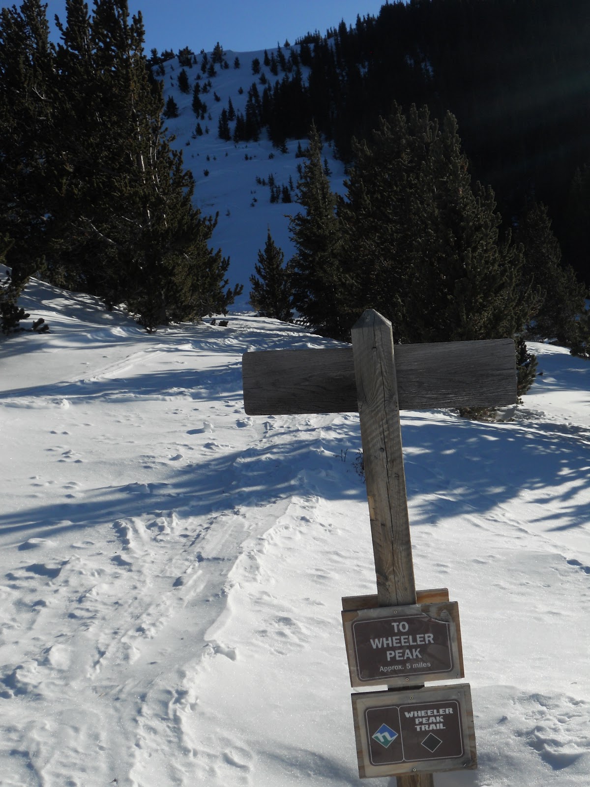
The wife and I spent our New Years in the backcountry near Taos. Specifically, we hiked into the Bull-of-the-Woods yurt two miles northeast of Taos Ski Valley. From our toasty wood-stove fired base camp our party spent the holiday-weekend roaming around the nearby hills by ski and snowshoe. There's plenty of terrain to tour around on nordic skis as well as some decent backcountry skiing on the slopes of Gold Hill. I was drawn like moth-to-flame to the Wheeler Ridge which stretches south from basecamp toward the highest point in the state, Wheeler Peak, 13,161ft.

Grabbing the first ascent of the new year seemed pretty keen to me so while the others were out ski-touring I taped up my heels, stepped into my boots, and set off up the trail on a New Year's adventure run with three hours of daylight and a mostly full moon to light the way.

bull woods yurt nm
Base Camp

Wheeler Peak trail taos
Through tree-cover to the ridgeline. Light-footing the drifts to avoid death by post-hole
Fast and light. Snowshoes for impassable sections

Wheeler Peak trail taos
Taos Ski Valley in the distance
Wheeler Peak trail taos
Just 5mi to Wheeler, up a few hills

Wheeler Peak trail taos
Gaining the ridge. Some evidence of trail though better footing to be found off trail

Kachina Peak New Mexico
Big-horn sheep, a ram and ewe. Taos Ski Valley and Kachina Peak in the distance (12,481ft)

Big horn sheep nm
I steered well around these two. They didn't have interest in me either fortunately
Wheeler Peak ridge Taos
I thought Wheeler might be behind that big guy top left. My route crossed through the bowl to the left

Wheeler Peak ridge Taos
Gunning for the high ridge in fading light. It was beautiful

new years sunset mountains
To the west, the first sunset of the new year

Latir Peak Wilderness
To the north, the ridgeline approach, the Latir Peak Wilderness and Culebra range further north, the Spanish Peaks far right, Blanca Peak range distant center-left

Wheeler Peak New Mexico
From my high point I see I'm short by a (very scenic) mile. Wheeler at far right
Fine effort, good run. A little brandy to power the return trip
Wheeler Peak full moon
The moon helps guide the run home

The trail was at least 6mi from camp to summit (a two mile head start from the trailhead). I felt like I was really moving and would steal the summit for certain. In the end there were four false summits on the approach and I made it up only three. Gazed across the fourth and destination-fifth (Wheeler) as the sun set behind the Jemez. The summit push was another 1mi+ of snowy and technical ridgeline, across and back in the dark, which didn't look like fun so I tipped some brandy in a New Years toast and turned it around. Well played Wheeler, well played sir.

Summit gear included gaiters, ski poles, snowshoes (precautionary), a headlamp and a thermos of hot chocolate and brandy. With the snow, the primary challenge was route-finding - and retracing the route on the return (super-important).

I was really excited to be out in a mostly-full moon. The lights of Taos Ski Valley shined invitingly from below the ridge as I ran along hoping from rock-to-rock and vaulting snow cornices with the aid of my poles. What would the new year bring? Anything I will it to I suppose. Nearly anything is possible if you just get out and make it happen.

Related Links

 - New Years 2010-11: Cumbres Pass Yurt, Neff Mountain CO


View Wheeler Peak in a larger map


Wednesday, October 26, 2011

The North Face Speaker Series

The Karakoram at dawn  - Cory Richards for Outside
Get an early taste of winter's snow capped mountains this evening with alpinist and photographer Cory Richards, guest speaker in this year's installment of the North Face Speaker Series. Cory will be presenting photos and details of his team's recent summit of 8000m peak Gasherbrum II. Q&A and athlete signing afterward. These guest visits have been a lot of fun the last few years, and this evening's iteration ought to dovetail nicely with the icy cold front moving in to the state. Bring it baby.

Free admittance. 7pm Wed 10/26 at the Armory for the Arts, Santa Fe. If you can't swing it fear not: Cory's photos and a recount of the expedition were published in the April edition of Outside Magazine.


Tuesday, October 4, 2011

Big Tesuque Trail Run Report - 2011


Big Tesuque 2011, Hadji, Eric and Mike lead out the field
Big T baby! Alright, what a fun morning. We had a damn fine group up there on Saturday, terrific weather and a whole lot of blue sky and scenery. From the looks of the pre-race crowd I figured we'd have a larger than normal field of racers but in the end we were about even with previous years. This preserves the ratio of coffee and burritos per racer so no harm done.

Well, it was obvious from the time of the starter's instructions how this thing was going to play out. Bernard Langat had come up to run and was the de facto champion before the gun even sounded. Former champion and trail racing royalty Rachael Cuellar as well as three time Big Tesuque champ Mike Ehrmantraut were in the field so there were the likely women's champ and men's runner-up. Eric Peters was lined up, Joachim Marjon was there, mountain-runner Jacob Waltz, Antonio Lopez, the esteemed Dave Simpson, Matt Dreier, and my ghost from last year Andres Santiago of Flagstaff was back. I talked with ultra-runner Ruthanne Hamrick, Caldera marathon runner-up Whitney Dreier, Erin Sindewald, Mariam Browne, Liz Jaramillo-Lopez, and Erica Micander. Who else showed up to run? You never quite know who's lurking at the start of one of these things.

Dale, supervising registration - photos by Max Mujynya
As for myself, I'd been off my feet a bit coming into the week but had my eyes on crushing the ascent. The downhill section would have to be a wait-and-see type of deal. A steep and technical downhill of pain and uncertain footing was not really going to help with the foot injury I'd been nursing. Last year the descent destroyed me, pretty much ending my running for several months. Ok, well with the gun, off we went. I eased on up the trail and found myself toward the front without much effort. I ran for a bit near Rachael and thought she might just be taking it easy over the first section, but we hit the first mile in 8:22 so it seemed we were both moving well. Feeling good, I just hammered away with my choppy little climbing stride at what felt like 200rpms. After the first couple miles Rachael had set up 50m ahead of me, Joachim was another 80m or so beyond her. The gaps didn't seem to move much the rest of the way up.
Liz Jaramillo-Lopez and William Ek leading a pack of runners at mile 1 - photos by Max Mujynya
Here's one of myself on the escalator lined in gold - photos by Max Mujynya

I was trying to get in a hard workout for the first time in several weeks and for that reason never did glance back to see what was behind me. I know that someone bridged a gap and ran up on my heels at around mile 3. It rankled that I was running slow enough to be caught so I boosted my turnover for a few minutes and the footfalls were gone. It probably took some work for whomever it was to move up onto my hip, and then when he arrived and could get a bit of rest I pressed ahead. That had to have sucked badly for him. However it made me feel like badass Clubber Lang handing out a beating. That happy thought carried me to the top and past the now descending front-runners. Bernard came jogging past near the chairlift. Mike came by at the steep hairpin. Joachim closer to the towers, then Rachel right up near the turn-around.

Assorted wildlife


At the mountain edge my watch stopped at 55m30s, my best climb by 2min. Fantastic except that I didn't think I'd be ahead of so many people at this point. If I could help it I'd rather stay ahead of them all until the finish. Quite the dilemma I'd found myself in. It started to slip away from me fairly quickly though. I lost my legs around mile 8, they just didn't have the miles in them to control the fast decent and I wasn't very confident that they could prevent a stumble or fall. I had to focus pretty keenly on the footfalls and keeping my strides and pace under control. Soon after, Mike Rahmer out of Albuquerque came blazing by with a long powerful stride and just disappeared. I felt an unpleasant bonk coming on and stopped for several cups of gatorade at the water stop at mile 9.5. Jake Lawrence and Andres Santiago sped by together as I stood there like a rube. Back on the trail I closed the gap on those two over the next mile, and then Andres jetted away out of view. As the trail leveled out a bit in the last mile I was able to sprint a few of the flat sections without the worry of falling on my face. I closed pretty well on Jake but ran out of real estate, but so did the guy behind me which I figured had to be Waltz. It was Waltz.

Bernard on the descent - photos by Max Mujynya
Rachael a few places back in fourth - photos by Max Mujynya
Whitney Dreier with the aptly named Aspen Peak in the distance - photos by Max Mujynya
Ok, good showing. My foot seemed stable and wasn't all jacked-up. I hadn't fallen hard on a bunch of rocks which is a big plus, and I had climbed strongly and avoided a complete tank on the descent. That's a pretty good hand son, maybe a full house. Mile splits on the way up were something like: 1/ 8:22, 2/ 10:00, 3/ 10:00, 4/ 9:30, 5/ 9:20, 5.9/8:18, descent/ 37:00.

Seeing that Bernard finished in a fast - but not record fast - time of 1hr 21min I asked him if he had been running hard. "No, no," he said (he's been running the trail all summer and reportedly put up a 1hr13m run in that time). He was getting in a workout for upcoming pacing duties at the Toronto Waterfront Marathon in two weeks. 81minutes on that trail is quick (the quickest time in the last 10yrs is 78min), and he took home some pottery and a certificate for a free pair of trail shoes from Alpine Sports. Joaquim Marjon moved into second on the downhill section, Mike Ehrmantraut finished third. Rachael ran away with her second women's title in roughly the same time she put up in 2009, 1hr 31min which is near the women's alltime record. The turn-around at the towers has moved a bit since the '09 race adding an extra minute to course times. She also received a trophy and free pair of trail shoes. Albuquerque's Stefanie Tierney held on for second, and Santa Fe's Whitney Dreier closed for third.

There were a number of falls in this year's race and the EMTs had their hands full. I know that Chris Chavez took a tumble, as did Kevin from Carlsbad, as did Vince Hesch, as did about a half a dozen others. No broken bones it seemed but possibly a few scrapes requiring stitches. Hope everyone was feeling a bit better the day after. 

Pete Fant did another standout job directing the event, his 14th straight year, and our fine sponsors provided support, race donations, and awards: Alpine Sports, San Francisco St. Bar & Grill, Santa Fe Screen Printers, Souder Miller Engineering and Survey, Paseo Pottery, The Santa Fe Striders, The Running Hub, Java Joes, and the Santa Fe Baking Company. Race proceeds, as always, benefit WINGS of America running club. Hope to see you all again next year.


Annie McCoy, Melissa Smith, & Mariam Johnston - photos by Max Mujynya

                                        Overall Results - Big Tesuque Trail Run 2011
Finish Name Time
1. Bernard Langat, 1:21:39
2. Joachim Marjon, 1:27:07
3. Mike Ehrmantraut, 1:27:48
4. Mike Rahmer, 1:30:45
5. Rachael Cuellar (W1) 1:31:21
6. Andres Santiago, 1:31:42
7. Jake Lawrence, 1:32:22
8. Kevin Brennan, 1:32:27
9. Jacob Waltz, 1:32:49
10. Hadji Corona 1:33:39
11. Peter Vigneron 1:34:17
12. Eric Peters 1:37:13
13. Matt Dreier 1:38:24
14. David Schoenwald 1:39:32
15. Dale Hoskisson 1:40:00
16. Antonio Lopez 1:40:46
17. Kyle Dickmen 1:41:32
18. Dave Simpson 1:41:41
19. Robert Baker 1:42:06
20. Vinnie Kelley 1:42:51
21. Stefanie Tierney (W2) 1:42:54
22. Herman Agoyo 1:43:11
23. Chester Tepple 1:45:20
24. Philippe Muller 1:46:51
25. Jeremy Milligan 1:48:41
26. Dan Tallon 1:49:19
27. Alden Hoskie 1:51:01
28. Brandon Johnson 1:51:05
29. John Wilp 1:51:21
30. Ty Lujan 1:51:39
31. Whitney Dreier (W3) 1:52:17
32. Jose Nava 1:52:50
33. Laura McClellan 1:52:57
34. Erin Sindewald 1:53:53
35. Mariam Browne 1:53:58
36. Shawn Edwards 1:54:00
37. William Dearholt 1:54:23
38. Vine Hesch 1:54:56
39. Luke Washburn 1:55:56
40. Ruthanne Hamrick 1:55:58


Full results and Max's photo albums can be found here

Waltz has his race report up here:
2011 Big Tesuque Trail Run

Last year's race report can be found here:
Big Tesuque - 2010


View Aspen Vista Trail (Big Tesuque Trail), Santa Fe, NM in a larger map


LinkWithin

Related Posts Plugin for WordPress, Blogger...